21st Century Tranist
I write to help me learn and grow as a professional, demonstrate my knowledge, flesh out and organize my ideas and analyses, and enjoy a free and flexible outlet.
All articles are posted here on this website. Some articles I keep more private and are exclusively posted here, some are also posted on my Substack account.
Regional rail for a more connected Jacksonville
Jacksonville's First Coast Commuter Rail has given us a glimpse of what's possible. Yet, like other bold ideas for transit in the U.S., the process has dragged out and is still just an idea.
Like most midsize major American cities, Jacksonville once had the ambition to enhance transit with bold ideas. But, also like most American cities, it struggled to make these projects come to life.
After almost two decades of planning and studies, the city’s First Coast Commuter Rail (FCCR) initiative has made little progress toward actually becoming a reality. According to my hours of deep research—and my conversation with a plugged-in transit advocate from the Jacksonville area—it’s pretty clear that regional rail is not happening anytime soon, as there have been no public updates on FCCR since the end of 2023. Further, JTA is focusing on other flashy projects that serve no real purpose and are an expensive alternative to adding a few new bus routes.
But still, as a frequent visitor, I wanted to look more into JTA’s plans and the potential for a great system.
The evolution of FCCR proposals
In 2008, JTA hired a consultant to conduct a feasibility study to assess the different route options for the service. The report, completed in July 2009, started by identifying 9 possible corridors. After briefly examining each one, the study selected the top 3 to evaluate more in-depth.
The final 3 corridors were (also see Image 1):
CSXT Kingland Subdivision: Runs north up past Jacksonville International Airport into Nassau County, terminating in Yulee.
CSXT Sanford Subdivision: Runs southwest to Clay County, terminating in Green Cove Springs. (A segment of Amtrak’s Floridian and Silver Meteor routes).
Florida East Coast Railway (FEC) Main Line: Runs southeast into St. Johns County, terminating in St. Augustine.

Image 1: Top 3 corridors in the 2009 study. (Source: JTA)
In the end, the FEC Main Line to St. Augustine was the selected corridor for FCCR service.
Bringing trains back to downtown
Jacksonville’s current Amtrak station is about 5 miles northwest of downtown in the middle of a multimodal freight hub. The area is not walkable, with no attractive development nearby. It is surrounded by surface parking, truck storage in industrial yards, vacant plots of land, and a train yard. (see Image 2). The only housing that is close by is low density and across a wide and busy stroad.

Image 2: A Google Earth screenshot of the current Jacksonville Amtrak station and the surrounding area. (Source: Google Earth, edited by me)
A big part of JTA’s plans for FCCR was to repurpose the old Jacksonville Terminal downtown back into a train station and integrate rail service with the other travel modes at the Jacksonville Regional Transportation Center (JRTC). This would enable rail passengers to make easy transfers to JTA’s bus system, the Greyhound bus station, the Skyway monorail, and the Ultimate Urban Circulator system (currently in testing phases).
If FCCR becomes a reality and Brightline eventually follows through with plans to extend service up to Jacksonville, the city is going to need a bigger station with sufficient capacity and a better surrounding area. Reviving the old station would accomplish both:
There is plenty of space to build multiple platforms and new tracks on the FEC right of way that passes by the old Jacksonville station.
While downtown Jacksonville still needs more redevelopment, it certainly beats the current train station location.
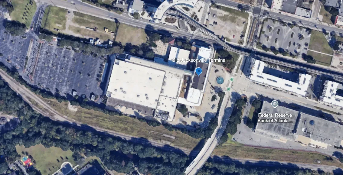
Image 3: Old Jacksonville Terminal next to the existing tracks with space to spare. (Source: Google Earth, edited by me)
JTA not only wanted to bring trains back downtown, but it also worked with the Downtown Investment Authority to lay out ambitious plans for redeveloping the surrounding neighborhood (see Images 4 & 5). A project overview from the end of 2022 and a 2023 transit-oriented development study show bold ideas for a new walkable and lively neighborhood around this new transit hub.

Image 4: Screenshot from JTA’s 2022 project overview. (Source: JTA)

Image 5: Screenshot from the 2023 TOD study. (Source: JTA and WSP USA)
The latest proposal
The most recent proposal for the FCCR network was presented in a transit-oriented development study completed by WSP USA for JTA. The report identified 15 potential stations and studied each one pretty comprehensively for potential development around them. JTA’s consultant then selected the top 7 to assess more in-depth (also see Image 6).
The 7 selected sites:
Jacksonville Regional Transportation Center (JRTC); downtown Jacksonville
Baymeadows
Avenues Walk
US 1 / County Road (CR) 210
Palencia
King Street
State Road (SR) 312
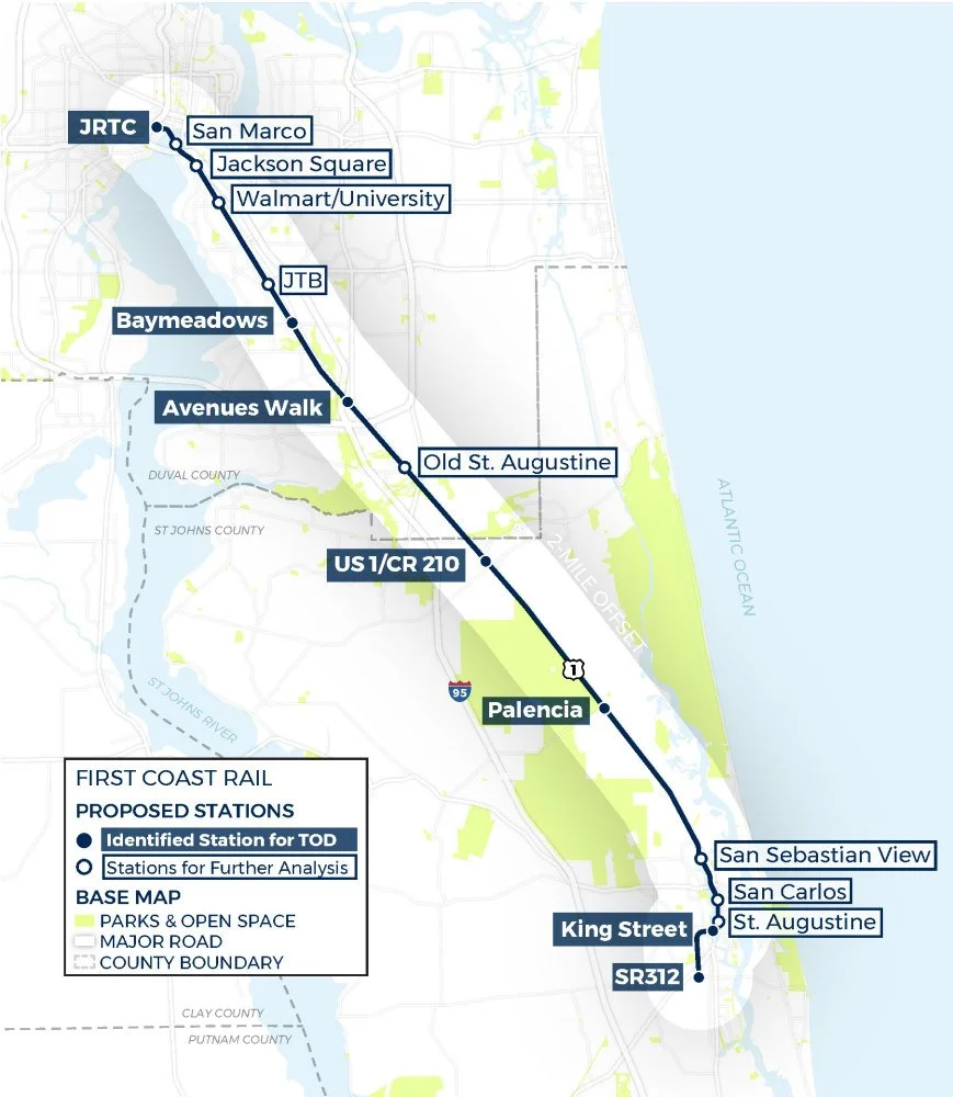
Image 6: Map of 2023 TOD study station site candidates. (Source: JTA and WSP USA)
According to the report, these locations are the top candidates for FCCR stations. The study evaluated these sites based on current readiness with population and existing developments and the best potential for future growth.
Speed and runtime
The route is 38.4 miles long and a 2022 proposal estimated a runtime of 48 minutes from JRTC to St. Augustine. However, that plan only featured four stations and terminated in downtown St. Augustine, not going all the way to SR 312 which is another two miles south. These additions would push runtimes closer to an hour.
How can we get the most out of this network?
Let’s forget about this project’s limited resources and the process that has dragged it out over so many years. I want to explore an alternate reality where JTA has the resources and will to build a robust rail network that connects the entire Jacksonville region.
Here are some of my ideas:
I have no planning, engineering, or architectural background. Part of the goal of this publication is to document my educational journey in those fields. If you have an education, working experience, or general knowledge of these concepts and railroad operations, I welcome comments with critiques, corrections, and thoughtful discussion to help me learn.
Add service on the north and southwest corridors
Investing in service in all three corridors would create a complete network covering the Jacksonville region and spark new growth throughout it.
Through-running for better connectivity
Through-running is exactly what it sounds like. It is where regional trains come from one branch of stops in suburban towns, run into the major city center, and then continue onto another branch to surrounding suburban towns on the other side.
Image 7 is a great visual aid for understanding through-running created by Liam Blank, a New York-based Urban Mobility Strategist who has written several great articles on the topic.
Image 7: Graphic comparing traditional stub-ended commuter rail to through-running regional rail. (Source: Liam Blank, accessed via liamblank.com)
What would through-running look like in Jacksonville’s regional rail network?
Northbound trains from the southeast branch will come into Jacksonville, stop at the station, and then continue north to the Yulee branch; southbound trains will go from Yulee to St. Augustine.
Trains will terminate and turn around at the end of each branch, not at JRTC. This creates a regional rail line that connects St. Augustine to Yulee and everywhere in between with a one-seat ride, no transfers necessary.

Image 8: Map from 2009 study, showing the coverage if the Yulee and St. Augustine branches were connected. (Source: JTA)
To make this a reality, it will require some work.
As shown in Image 9, new tracks will have to be built from the TTX Acorn Yard through the industrial yards and an old abandoned railway that runs through the center of the city that was turned into a walking trail.
The repurposed walking trail—the S-Line Urban Greenway—will eventually connect to the existing right of way that runs north up to Yulee.

Image 9: Map of downtown reviving abandoned downtown right of way to connect southeast branch to northern branch. (Google Earth, edited by me)
If you look closely at the map from the 2009 proposal, it appears repurposing the trail back into a railway was part of the original plan for the northern corridor.

Image 10: Close-up screenshot of the 2009 corridors in Jacksonville city center. The north branch runs a similar alignment to the existing walking trail. (Source: JTA)
We can also tell by looking closer at the map why through-running on the southwest corridor is not possible as it is currently laid out relative to JRTC. If you look at the screenshot from openrailwaymap.org (Image 11), southwest trains would have to connect to the tracks that approach JRTC from the northwest. This means trains cannot run straight through the station and just continue north onto the Yulee corridor; they would have to turn around.
That is not through-running.

Image 11: Screenshot of OpenRailwayMap of downtown Jacksonville. (Source openrailwaymap.com)
The only through-running route possible is St. Augustine to Yulee. While most passengers from St. Augustine may not be looking for a direct trip to Yulee, there are still many travel possibilities in between.
The idea of through-running sounds even better if some trains went directly to Jacksonville International Airport.
New right of way to the JAX terminal
Building a station along the existing right of way to Yulee with a shuttle service would be a lot easier and cheaper, and is not a terrible plan. But trains running directly to the terminal would truly be a game-changer. A one-seat ride without transferring to a shuttle bus is always better and will make the regional rail service a more attractive travel option.
On Google Earth, I sketched two potential routes (orange and blue) that branch off and carry trains between the northern main line to Yulee (green) and a new approach to the terminal (yellow).

Image 12: Screenshot from Google Earth with my sketches for potential direct connection to JAX terminal. (Source: Google Earth, edited by me)
Terminal approach on Airport Road

Image 13: Screenshot from Google Earth with my sketch for the route approaching the JAX terminal. (Source: Google Earth, edited by Transit Visions)
Airport Road is a wide road with a good-sized median that could easily fit a new elevated railway. Once trains reach the loop, they will run parallel to car traffic—counterclockwise—on the inside of the loop (to the left of the road).
A new small station will be built right next to the existing parking garage or somewhere close that allows a direct walk to the terminal. After droping off and picking up new passengers, trains will depart and continue running along the road until they reach the end of the loop and merge back into the main artery over Airport Road.
This is the easy part of building a direct connection to the airport. The hard part will be branching off the existing right of way to Yulee and connecting it with the Airport Road elevated track.
At a glance, I see two options.
Branch #1: Airport Center Drive

Image 14: Source: Google Earth, edited by me
This option starts with a new ramp that will branch off from the main line to Yulee and connect to an elevated track in the middle of Airport Center Drive. The right of way will continue west toward Interstate 95 where it will connect to the approach on Airport Road.
Like Airport Road, Airport Center Drive is also a pretty wide road separated by a spacious median, making it a suitable corridor for an elevated track. The issue here is crossing I-95, which passes over Airport Road. So if an elevated railway is built off the initial branch and connects to an elevated railway on the other side, it’ll have to be really tall.
Branch #2: I-295 and I-95

Image 15: Source: Google Earth, edited by me
The second option is to build tracks where trains branch off the Yulee line at I-295, and then run along I-95 until it reaches Airport Road where it will connect to the approach.
While building around the highway may be tricky, there appear to be some options to construct elevated tracks between medians and ramps over and around car traffic to make this route to connect to Airport Road possible.
Let’s reimagine daily travel in America.
I want to explore the possibilities for a future with safer, cleaner, more comfortable, more equitable, and more efficient travel transit-deficient regions like Jacksonville.
We can make them happen. But we have a lot of work to do, and it starts with breaking down the stigmas and myths that have shaped the perceptions of mass transit in this country. Part of that is exploring what is possible with fully funded investment in improving and expanding our systems.
Presenting vision.