21st Century Tranist
I write to help me learn and grow as a professional, demonstrate my knowledge, flesh out and organize my ideas, and enjoy a free and flexible outlet.
All articles are posted here on this website. Some articles I keep more private and are exclusively posted here, some are also posted on my Substack account.
Barcelona La Sagrera: A modern-day mega-station
The future of multi-modality and city-building is under construction in the Catalan capital.
After our time in France, we made our way to Spain, where we saw a central rail station and “a new urban center” being built from scratch in Barcelona when we visited the construction site of the future La Sagrera Station.
There, we got a presentation and site tour from a few planners of Barcelona Sagrera Alta Velocitat (BSAV), the public commercial company that was created by Spain’s Ministry of Public Works, the Government of Catalonia, and the Barcelona City Council to oversee the station’s planning and construction. Translated to “Barcelona Sagrera High Speed,” BSAV also coordinates the rail and transport improvement projects and urban development related to this station project and occurring in the Sagrera, Sant Martí, and Sant Andreu neighborhoods in northeast Barcelona.
BSAV has a building right next to the construction site, where we got a great presentation from several members who filled us in on this transformational project.
Barcelona needs a new station
Our group’s train from France went through Barcelona-Sants station, the city’s current main central station, and it was immediately clear that Sants isn’t up to being the modern gateway to the city. After going through and touring some of France’s great stations and station neighborhoods, we were pretty underwhelmed with Sants. We arrived on a Wednesday afternoon to a busy and hectic environment. We weren’t packed in like sardines, and it wasn’t too difficult to move about the station, but it wasn’t very comfortable either.
The modern version of the station opened in 1975. After the rapid expansion of Spain’s high-speed rail network since the 1990s, it has struggled to meet the demand of 46 million annual commuters and accommodate new high-speed rail operators. Even though Sants is undergoing its own large-scale renovation, Barcelona needs another station to take on some of its traffic.
But don’t just take my word for it, BSAV and its partners are fully aware of the current capacity issues and the significance of a new station. Our hosts told us they are expecting Sagrera to split the traffic through Sants in half, and forecast 100 million annual passengers eventually. A new large center city station is something Barcelona really needed and, luckily, there was an opportunity for the taking.
The perfect plot of land in the perfect location
Old cities are often landlocked to new large-scale development, unless they want to raze historic parts of their cities at an astronomical price tag. Most historic cities are stuck with the main rail station(s) they’ve got. However, for Barcelona, a 200,000 square meter chunk of land in the northeast part of the city, already connected to other rail lines, was sitting right there for the taking: the site of an old freight rail station.
The railway line that goes through this old freight hub was built in the mid-1800s, and the station was built in 1918-1922. It is one of the largest railway areas in Barcelona, but had been underutilized for many years.

The old La Sagrera freight station site. (Source: BSAV)
Because of the large railway area that cuts through this part of the city, it’s an area that could definitely use a facelift. The surrounding neighborhood is made up of old residential buildings, and the area immediately around that station had lots of scrap yards and slum-like homes. There is very little activity in the neighborhood, something BSAV is hoping to change:
“The construction of the high-speed line and the new Sagrera station represent[s] an opportunity to renovate and recover obsolete industrial areas, large areas dedicated to the railway and infrastructures for energy and sanitation that had been isolated.” — BSAV
The station and station area
The station complex will total 300,000 square meters. The station itself will be mostly underground, while ground level will be the main lobby surrounded by El Parc del Camí Comtal—the large urban park being built with the station. The BSAV website calls this area “connection yard” or “intermodal yard” with access to the Sagrera neighborhood and open urban space.
Going underground into the actual station, there will be four levels—two levels for platforms with a total of 18 railway tracks. The upper level will house high-speed trains and 19-bay intercity bus station. Main access will be from the mountain side, or northwest side from the La Sagrera neighborhood. Here, there will be a large connection lobby for the metro and buses. Departures are will be to the north, arrivals will be on the south side. The two lower levels will be used for commuter rail services, the metro, and parking. Its main access will be from the seaside, or the southeast side from the Sant Martí neighborhood.

Diagram of station levels. (Source: BSAV)

3-D rendering of the station and station area showing different levels. (Source: BSAV)
Here is a clearer breakdown of each level:
Sub-level high-speed rail platforms: The first level down will be the platforms for high-speed rail trains with 10 tracks total. BSAV has this level as “semi-underground” and says it will get natural light with easy access to the main lobby on the floor above, as well as another concourse below.
Underground concourse: This concourse area is below the high-speed rail tracks and above the platforms and tracks for regional Rodalies trains. This will enable travelers to pass through the station, whether between HSR and Rodalies trains or from one of those services to the metro, local and intercity buses, taxis, and parking.
Bottom-level platforms: The lowest level down will be the Rodalies regional train platforms, which will have 8 tracks.
Our presenter from BSAV actually mentioned the San Francisco Salesforce Transit Center, another multi-level station under construction, as a similar comparison. The two station building projects are transformative for their respective cities, both are similar and different in many ways, something I plan to cover in a future article.
Sagrera is the centerpiece of a “new urban center”
The objective is for the new Sagrera station to be bigger than just a major intermodal public transportation hub, but a new central urban district that will drive a socioeconomic revitalization of north Barcelona. Around the station, 10,000 new housing units are to be built—40% of which will be social housing—and office and commercial space for 30,000 new jobs.
Part of BSAV’s plan vision is achieving greater social cohesion by reducing movement between places where people work and live and enable people to live in the same area as where people work and establishing “territorial identity.” They envision doing this by:
Planning hotels and offices around the station, for ease of accessibility for commuters and travelers.
Housing and local amenities spread throughout the district dispersed throughout the area.
Other commercial and tertiary activity clusters concentrated in specific areas.
El Parc del Camí Comtal
Around this grand new station will be a grand new urban park: El Parc de Camí Comtal.
This massive new urban park will be the ground level of the station area and over the railway track approaches 8 km long up to the north. A total of 38 hectares of underground rail and road infrastructure, that connects to the ring road and highway networks, will be buried under the park. This isn’t just any park, it’s a large urban park that is roughly the same length as New York’s Central Park.

Rendering of rail and road infrastructure under the planned park. (Source: BSAV)

Central Park and the future El Park del Camí Comatal. (Source: BSAV)
Our presenters gave an interesting history on European urban parks and why Barcelona is “park poor.” He said that other European capitals have park spaces from old royal hunting grounds, but Barcelona was not a capital, so it did not build many parks. Today, there were few opportunities, if any, as good as the Sagrera station site and the track right-of-ways to add new park space for the city. Barcelona has taken advantage of a blank canvas, and it's giving 180,000 nearby residents and travelers who pass through a giant new outdoor greenspace to enjoy.
Facilitating comfortable walking and biking within the neighborhood.
The main benefit of the park is that it will connect a historically divided area of Barcelona. Our presenters said that with the station area and the park that they are removing a “historical urban scar” since the railway was first built in the mid-1800s.
Currently, there are just a handful of bridges that connect the Sant Martí and Sagrera neighborhoods over the railway tracks. With the completion of the park, walking between the neighborhoods will be like crossing the street, creating a truly walkable neighborhood. There will also be a two-way cycle paths that runs parallel to the railways the entire length of the park with many connection points to the rest of Barcelona’s cycling network.

A diagram of the new connectivity with the park. (Source: BSAV)
Sagrera is the centerpiece of the future of multi-modality
Sagrera Station is going to have a massive impact on travel all scales, from local residents to people throughout Spain and Europe.
High-speed rail in Spain and Europe
The expansion of high-speed rail has led to much faster travel to and from Barcelona in all directions. When the line to Madrid opened in 2008, travel time was cut from more than six hours to around three hours. Going north about 101 km (or 63 miles), the city of Girona was once around a 90-minute trip, now its closer to 38 minutes. All the way closer to the French border about 144 km (90 miles), Figueres was once a two-hour trip, now it is 53 minutes.
The La Sagrera Station project is a central piece to all of these railway improvement and expansion initiatives. Because of Barcelona’s "privileged" location, BSAV envisions it will be the main node of the Central Corridor—Madrid-Barcelona-France—and the Mediterranean Corridor, which is planned expansion to the south of Spain and all through southwest Europe along the sea the corridor is named after. BSAV states Barcelona will be the capital of one of Europe’s “macro regions”—”Barce-Lyon.”
“Barcelona’s privileged location will in fact turn it into the capital of a macro region that is beginning to take shape on the map: ‘Barce-Lyon’, one of the 12 macro regions which, according to the experts, will make up the centres of economic, territorial and social power of the future of Europe.” — BSAV

Barcelona as a hub for Western Europe’s high-speed rail network. (Source: BSAV)

A diagram of different corridors on the Madrid–Barcelona–French lines with the years they opened. (Source: By Classical geographer, accessed via commons.wikimedia.org)
The French and Spanish high-speed rail networks connect right at the La Sagrera Station site; the station is the literal connection point of Europe’s two largest high-speed networks. To the south, the Madrid–Zaragoza–Barcelona high-speed line; to the north, the Perpignan–Barcelona line.
In 2013, the 5.6-km Sants-Sagrera city center tunnel was built and the 131-km-long segment of Barcelona–Figuerescorridor—the segment of the Perpignan line that is in Spain—were both completed and connected at the Sagrera station site. Since then, trains have been able to run from Madrid through Barcelona-Sants to the French high-speed network and some Catalan cities along the way. Since the end of 2024, trains have been passing through the station site, and our train was one of them!
The Sants–Sagrera central city tunnel: Through-running for better connectivity
La Sagrera Station would not be as impactful without the city center tunnel that was built to connect it to Sants. This 5.6-km tunnel runs through the heart of Barcelona, connecting its two main stations from different ends of the city—Sants to the southwest, Sagrera to the northeast.
The BSAV website clearly states all trains will stop at both stations, which opens up new local travel possibilities by providing heavy rail riders with two options for boarding and alighting in completely opposite ends of the city center at hubs with different connections to local transport networks. This is great for local, last-mile travel, as it will be easier to go to and from many new origin and destination points all across the city.
The tunnel has already unlocked national and international connectivity by being a key link between the Madrid corridor and the high-speed line up to France. When Sagrera opens, all high-speed rail travelers arriving or departing from Barcelona will get to choose a station more convenient for them, something not really an option right now.

A map of Barcelona with indications of its large rail statons. The Sants–Sagrera city center tunnel indicated by the dashed blue line. (Source: BSAV)
Rodalies de Catalunya rail service
Rodalies de Catalunya is the regional rail service Catalonia, mostly centered around commuter service for Barcelona. There are 17 lines—three variations of R2, totaling 19 different services—that serve about 350,000 people every day over a 290 track miles.
La Sagrera Station will be served by four(ish) lines:
R1: A 60-mile route with 31 stops, running from northeast in Macanet-Massanes in the mountains, then goes east close to the coast, then turns south and runs all the way through central Barcelona to just outside the city to the southwest.
R2: An 83-mile route with 34 stops that begins in the city of Granollers in the north and also runs through the center of Barcelona to the municipality of Castelldefels to south.
R2 Nord (R2N): A variation of R2 that begins at Macanet-Massanes, but it goes directly south, staying inland. It runs on the normal R2 line through the city, but then splits off the mainline and turns south toward the coast to stop at the airport, its southern terminus.
R11: A 107-mile line with 28 stops that stretches much further north to the small French coastal city of Cebere, just on the other side of the border. From there, it runs through a dozen cities, including larger cities of Figueres and Girona, to Macanet-Massanes, where it joins R2N and runs on that route until Sants Station, its southern terminus.
These lines come together at the future La Sagrera Station site and share the El Clot-Árago Tunnel with R11 through central Barcelona to Sants Station.

Rodalies de Catalunya map. Look closely at the right side of the map to get a good look at the lines that will run to La Sagrera. (Source: Renfe)
From what I could tell, R1 and R2 are amongst the busiest out of the system’s 21 total services. I could not find a reliable source for post-pandemic ridership data by line, so I do not want to put out any misleading numbers, but I can sort of paint a picture based off of 2016 ridership numbers I was able to find.
In 2016, Rodalies de Catalunya served 117 million passengers total. R2 carried the most passengers with a ridership of 33.6 million riders, and R1 was the third-highest at 28 million. In 2024, Renfe served 127.4 million passengers on Rodalies de Catalunya. So, ridership has more than rebounded since the pandemic, and I don’t think it’s incorrect to suggest that the ridership on these lines is a little bit higher than those numbers in 2016.
La Sagrera will be a massive hub for Roadalies rail travelers as well. Plus, with R2N connecting to the airport, which also further enhances national and international travel connectivity through La Sagrera, someone arriving in Barcelona on a plane is just one transfer away from a regional train away to a high-speed train.
Connections to local transport networks
The station is expected to serve 100 million annual passengers per year across all these modes. I could not find a breakdown of the projected mode split for the 100 million estimate, so I provided one based on an older estimate of 92 million passengers per year to give an idea of how the station will be used:
22.5 million for HSR
30 million for regional trains
15 million for metro
12.2 million for road transit; buses and private car
The high-speed rail and the Roadlies de Catalunya lines mentioned before that will soon stop at La Sagrera currently run into Sants station, which connects to Metro L3 and L5 along with a handful of bus lines. R2, R2N, and R11 also stop at the rebuilt Sant Andreu station a couple of miles to the north of La Sagrera, which is close to a Metro L1 stop, but it’s not necessarily an interchange point.
New expansions of the local transit network are taking place alongside the construction of La Sagrera to fully maximize its potential as a multi-modal hub.
Metro connections
La Sagrera will be served by three Barcelona Metro lines that are being expanded and adding stops on their existing routes.
Metro L4 is a funky, loop-like line within the city. It begins at La Pau, which is just east of the Sagrera station site, it goes down south through the city center, close to the coastline, turns inland (west), then back up north, running to its terminus at Trinitat Nova, northwest of La Sagrera.
For the Sagrera station project, L4 will be extended 3 stops west from the La Pau stop. The second extended stop will be at La Sagrera station, and then going one more stop to the La Sagrera-Meridia Station, which connects to R3 and R4 Rodalies services.
The other two lines that will connect to Sagrera are L9 and L10, though they will be interlined into their shared trunk line in this part of the city, so it will be one station. The L9/L10 expansion is one of Barcelona’s highly-touted transport projects in recent years, and has been subject to acclaim for its unique tunneling and station building methods in an attempt to save on costs. However, like the Sagrera station project, it has run into a series of construction and financial issues since work began in the 2000s, which were exacerbated by the 2008 financial crisis.
These two lines are currently open in the northern and southern parts of the city, operating as short lines in two separate segments as work continues on fully connecting them through the city center. There is already a La Sagrera station on the northern part of the line that connect to two other metro lines there. When the La Sagrera station is complete, it will be the La Sagrera-TAV Metro station.
The L4 and L9/L10 stations will run parallel to each other and share the same main access lobby to and from the rest of the La Sagrera complex.

Diagram showing Metro and Rodalies lines stopping at the future La Sagrera Station, indicating future extensions of L4 and L9/L10. (Source: BSAV)
Road connections
What I find so brilliant about the motor vehicle access in the design in and around La Sagrera is how connections to local roads, ring roads, and expressways will be “plugged into” the station through underground tunnels to and from the station. While there will be car and bus access on both sides of the station, motor vehicles will, for the most part, be out of the way and not disrupt the urban fabric or pedestrian comfort in the area.

Road connectivity to and from La Sagrera Station. (Source: BSAV)
The connection to ring roads and other roadways outside of Barcelona will provide easy access for local and intercity bus routes entering and leaving La Sagrera’s new 19-bay bus station, which will handle 480 intercity departures per day.
There will be a few vehicle lanes on the San Martí side of the station. However, if you look closely at the diagram below, there are multiple access points to the main concourse between high-speed rail and Rodalies train tracks for pedestrians. They are not required to cross a busy airport drop-off like a madhouse. While there is still good vehicle access to that side of the station, it does not dominate the space and its kind of on it own level. On the La Sagrera side of the station, there’s a tunnel for vehicles indicated by the label “G” that’s also easily accessible from the main concourse area. For those who wish to drive and park at the station, there will be two bilevel parking lots, one on each side of the station, to hold 2,500 vehicles.

Station diagram showing different levels and areas with labels. (Source: BSAV)

Rendering of entrance to station on the San Martí side of the staton. A level for motor vehicles, allowing close pick-up and drop-off access, separate from pedestrian access. (Source: BSAV)
The future of city building and multi-modality
In Lyon, my work-study group visited an existing station and central urban district getting a major facelift. It is an extremely impressive initiative and multi-faceted mega-project. I bring this up not to compare it to the La Sagrera project, but put into perspective what Barcelona is building here:
A new city center district—with jobs, housing and lodging, and other activities—with a brand new main city center railway station almost from scratch.
Taking a desolate and underdeveloped part of the city, seeing an opportunity, and making it happen is really inspiring. There are so many areas like the La Sagrera neighborhood, whether an abandoned freight station or another undeveloped post-industrial site, in parts of our many once-great U.S. cities that have been hollowed out. We could transform these cities, their metro areas, and entire regions if we looked at those places as opportunities with the same vision, creativity, and ambition as Barcelona sees for La Sagrera.
Modernizing travel between Missouri's two largest cities
From incremental improvements to building an entire new high-speed line, I explore the possibilities to improve rail service between St. Louis and Kansas City based on past plans and research.
Missouri is one of the handful of American states that has two major cities with large metro areas. Yet, travel between them has hardly changed in the last few decades.
Because the best Missouri and Amtrak can do is a 5.5-hour train ride, most by default just do the 3.5- to 4-hour drive on Interstate 70 or go through the entire painstaking airport experience for an hour-long flight.
But there was a time when the State of Missouri had ambitious goals for modern train service between its two major cities. Through various reports and proposals, the Midwest Regional Rail Initiative (MWRRI) and the Missouri Department of Transportation (MoDOT) laid out a transformative vision for much faster and more frequent trains than the state and Amtrak operate today.
Had those plans been implemented, traveling across the state would be faster, safer, more comfortable, and more environmentally friendly than it is today.
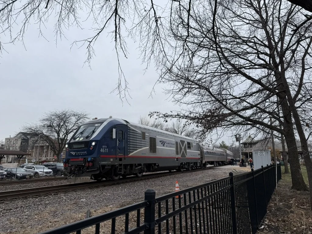
Image 1: A Siemens SC-44 Charger pulling an eastbound Missouri River Runner service stopping at Kirkwood Station. (Source: me)
Unlocking the Missouri River Runner’s full potential
The Missouri River Runner is Amtrak’s state-supported route between St. Louis in Kansas City, with 8 stops in between. This twice-daily service is the present-day consolidation of Amtrak’s old cross-state routes: the Ann Rutledge and Missouri Mules, which were merged together in 2009.
As for actual changes to the service itself, unfortunately, not much has changed over the years.
When I was a little kid, my family and I would travel to Kansas City around the holidays every year on Amtrak. In the early 2000s, the train averaged 50-60 miles per hour, topping out at just over 70 mph with a scheduled runtime of 5 hours and 50 minutes. Today, the average and top speeds are the same, and the scheduled runtime is barely faster at 5 hours and 40 minutes.
The only large improvement in recent years was the construction of a 9,000-foot passing loop near California, Missouri in late 2009. It was successful, as ridership grew, but the goal of the project was to reduce conflicts with freight trains to improve on-time performance. Make no mistake, this was not to achieve higher speeds and reduce runtimes, but simply to make sure trains actually ran on time. This is the only “upgrade” that has been made between the last time I rode the train when I was 5 or 6 years old to when I took it for the first time in almost two decades in December 2024.

Image 2: Existing Missouri River Runner route. (Source: jkan997 - http://sharemap.org/public/Amtrak_Missouri_River_RunnerGeospatial data sources: Open Street Map Data (ODbL) - http://www.openstreetmap.org/copyrightNORTAD - http://www.bts.gov/publications/north_american_transportation_atlas_data/Natural Earth - http://www.naturalearthdata.com/, CC BY-SA 3.0, https://commons.wikimedia.org/w/index.php?curid=29259405)
From the late 1990s to the early 2010s, the MWRRI and MoDOT had plans for significant service improvements through incremental upgrades to infrastructure. They wanted to enable top speeds of at least 90 miles per hour, with hopes of eventually exploring the feasbility of 125 mph and slashing runtimes to under four hours. They also wanted to start running six or more round-trip trains a day.
The goals outlined by the MWRRI and MoDOT were not just arbitrarily stated; they were actual studied solutions to increasing train speeds.
Double-tracking
A PE/NEPA application in March 2011 laid out plans to connect existing sidings that together would form a second mainline track on the Union Pacific Sedalia subdivision, which is between Pleasant Hill, MO, and Jefferson City, MO. This would’ve eliminated bottlenecks to allow Amtrak trains to reach and maintain speeds of at least 90 miles per hour, but the segment is still mostly single-tracked today.
Tilting trains
Even with eliminating freight bottlenecks, the route’s curves limit how fast trains can go. In a 2004 report, the MWRRI stated that tilting trains could safely reach speeds up to 90 miles per hour on most of the route’s many curves and help reduce runtimes to 4 hours and 42 minutes.
Grade-crossing improvements
MoDOT identified at-grade crossings that needed new lights and gates and wanted to explore the feasibility of sealing several of them off completely. These measures would not only improve safety, but allow higher speed limits through those areas.
Getting runtimes to under 5 hours is possible and would be a significant improvement, but this specific corridor has its limits. Even if conflicts with freight trains could be eliminated, there are too many curves, and much of the terrain in central Missouri is very hilly.

Image 4: A Missouri River Runner train at St. Louis Gateway Station in April 2022. (Source: Bob Johnston, accessed via trains.com)
This corridor is great for a conventional intercity service that connects Missouri’s two major metro areas with its capital in Jefferson City and other great cities all on one line. But true high-speed express service can not be achieved here. For faster trains for travelers going directly between St. Louis and Kansas City, Missouri needs a new right of way that is straighter, flatter, can be electrified, and entirely dedicated to passenger trains.
A real high-speed rail corridor
St. Louis to Kansas City became a federally designated corridor in 2001. Over the next decade, MoDOT tried to acquire funding and implement provisions to identify and evaluate a dedicated high-speed rail corridor with long-term plans for 180 mph speeds and electrification.
Unfortunately, these plans lost momentum when Missouri State Legislators blocked funding for high speed rail, along with the other budget constraints. There is no mention of these projects or initiatives in any MWRRI reports or MoDOT rail plans past 2012.
However, these dormant plans were explored enough to give us a glimpse of what a dedicated route in Missouri would look like.
Building along Interstate 70
For a true, dedicated high-speed rail line between St. Louis and Kansas City, it would likely be built along Interstate 70. Compared to the Missouri River Runner route, I-70 is a pretty straight route, and the terrain throughout is much flatter.
There have been a few mentions of building a new right-of-way along Interstate 70 in past studies.
MoDOT I-70 improvement study
This 2001 report weighed a number of options for alleviating traffic on I-70.
While the “Selected Strategy” was to widen the highway and the consideration of building high-speed rail was discarded, the report suggested that the “extra-wide median” being built could be allocated for a high speed rail line in the future.
MoDOT is committed to the further consideration of this space by a future high-speed rail system, but is currently uncommitted regarding the reservation of this space for the specific purpose of highspeed rail. — MoDOT, 2001
Hyperloop feasibility study
Remember the hype around the Hyperloop? Well, in case you didn’t know, St. Louis to Kansas City was once a favored route.
While the initiative lost momentum because the technology is impractical, a feasbility study shows the viability of building infrastructure along I-70. In the report, I-70 was deemed a strong corridor not only because the right of way already existed, but that it was relatively straight and flat.
“The report confirms viability of the I-70 based route through an exhaustive examination of the social impact, station locations, regulatory issues, route alignments and rights-of-way associated with a new hyperloop system that would connect Kansas City, Columbia and St. Louis.” — Virgin Hyperloop One
NextSTL’s high-speed rail series
NextSTL is a local online source covering a range of urban topics and issues in the STL area. In 2013, it wrote a three-part series about high-speed rail in Missouri.
Part I discussed building a new dedicated right-of-way between Wentzville (STL area suburb) and Blue Springs (KC area suburb) along I-70. In those suburbs, the new dedicated high-speed line would connect to existing rail lines that run into city centers (see Image 5).
“By building a dedicated HSR track between Blue Springs and Wentzville, travel time could be slashed to an hour between those two cities and to less than two hours between the downtowns of KC and STL.” — Frank DeGraaf, Contributor, NextSTL
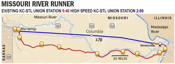
Image 5: Proposed high-speed line along I-70. High-speed line is blue, existing Missouri River Runner and existing railroads are red. (Source: NextSTL)
Electrification is not only a cleaner and more sustainable technology, but electric trains are faster and more reliable. Electrification is an advantage of building rights of way anywhere. As long as Union Pacific owns the existing MRR corridor, it is unlikely to be installed unless new regulations would encourage or incentivize it.
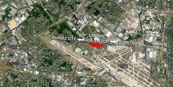
Image 6: Concept high-speed rail station near Lambert Airport, existing rail track rights of way, and Interstate 70 (Source: NextSTL)
Next steps
Missouri has a lot of work to do. If there’s a day the state decides to get serious about modernizing cross-state travel, here are a few first steps:
Missouri River Runner
Revive plans to study and/or secure funding for previously mentioned upgrades— tilting trains, double-tracking, and crossing upgrades.
Increase service frequencies to 10 daily round-trip trains, per the High Speed Rail Alliance’s recommendation.
High-speed rail
MoDOT should form a high-speed rail commission—like the Illinois High Speed Rail Commission—to study ridership, identify and design a corridor, make recommendations for planning a network, and propose a governance structure.
Lyon-Part-Dieu: An urban travel hub transformation
An up-close look at Lyon's generational urban project.
Paris isn’t the only French city that’s undergoing a massive transformation that’s centered around transport.
Lyon, France’s third-largest city and most important economic hub outside of the French capital, is undergoing a massive transformation in its central district around its main railway station. The local and regional governments are investing hundreds of millions of Euros into creating a new lively urban center with offices, housing, commercial activity, hotels, green space, and more in its Part-Dieu neighborhood.
A centerpiece to this transformation is Lyon’s main railway station, Gare de Lyon-Part-Dieu, one of Europe’s most significant travel interchanges. I, and a group of other students, had the chance to see it up close.
Lyon’s Part-Dieu neighborhood
After World War II, larger French cities were looking to create “decision-making centers” outside of Paris to balance the capital’s influence. The focus of French urban and regional planning was creating districts with thriving business, residential, and cultural activity. A key component of these neighborhoods was to have large transport hubs that were well-connected to the entire metro area, the region, and possibly nationally and internationally.
In the 1960s in Lyon, the military was leaving the plot of land it had occupied for the last 100 years in the Part-Dieu neighborhood. This presented Lyon with an opportunity to develop a new “decision-making center” in the heart of the city, and nearby was an old freight rail yard that was well-connected to the existing lines outside the city. An ideal scenario and layout for a new central city rail station.

Image 3: A map of Lyon with arrondissements (districts) outlined. You can see Part-Dieu in the center of the city, inside the borders of the 3rd arrondissement. (Source: Creator unknown, accessed via saxeandthecity.com)
In the 60s and 70s, Lyon pulled off some successful projects to develop the area, but ran into a lot of issues, one of the major ones I get into a little later in this article. From the mid-1980s to the 2000s, the reinvention of the Lyon Part-Dieu neighborhood had largely been put on hold. In 2011, it was back on the city’s and region’s radar. Since then, Lyon has been working on an ambitious urban renewal project, with one of the core ideals being “reinventing mobility.”
“Reinventier les mobilités”
Lyon-Part-Dieu (LPD) station is one of the busiest railway stations in France and one of the most significant connection points in all of Europe, including being one of the endpoints of the continent’s busiest high-speed rail line: LGV Sud-Est, the line between Paris and Lyon.
Since it opened in 1983, LPD station has been operating at well over its intended capacity of about 30,000 passengers per day. By 2000, it would be handling 80,000 per day. Today, it sees 135,000 to 140,000 passengers daily.
Staring down forecasts as high as 175,000–200,000 daily passengers by 2030, Lyon realized it was time to get serious about bringing their rail station up to modern standards and meeting their region’s travel demand. The local and regional governments of Lyon have been working with SNCF—France’s national railway company—for the last decade on renovations that will allow LPD station to accommodate 100,000 more passengers each day with the Multimodal Interchange Hub project.
More space for more passengers
A major takeaway from our tour with one of the architects was how they have identified the best opportunities for expanding the station’s footprint within the existing structure. Through a series of completed and ongoing projects, LPD station is adding more than 18,000 square meters of new concourse, waiting area, and retail space. Tripling its square footage.
These works are making for a more comfortable passenger experience by relieving congestion in the busy historic main hall and creating more access points to the station from all directions.
Here are some of the major works they’ve completed in the last few years (see Image 4):
Hall 2 Pompidou: A new concourse that is fully accessible—via stairs, escalators, and elevators—to all 6 platforms. It was built to help relieve congestion in the main hall by taking on an estimated 20% of the station’s traffic (see Image 3).
The Galerie Villette: A new concourse opened on the east side of the station in 2022 that added 4,000 square meters.
Béraudier Gallery: A multi-level gallery that opened four more access points to the station on the west side of the station. It added 10,000 square meters to the ground floor alone. Much of this expansion provided new commercial space.

Image 4: A picture of Hall 2 at Lyon-Part-Dieu, completed in 2022. (Source: Transit Visions)

Image 5: A diagram of the large station expansions at Lyon Part-Dieu from June 2024. (Source: lyon-partdieu.com)
LPD station has added a significant amount of space, but they aren’t done yet.
We got a sneak peek of the Hall 1 expansion that’s currently under construction. Behind the stairwells that lead up to the tracks, 1,300 square meters will be added in waiting area space, a 30% increase in space in the congested main concourse.

Image 6: Renovation site of Lyon-Part-Dieu’s main, historic train hall. (Source: Transit Visions)


Images 7 & 8: Construction site billboards for Hall 1 renovation. (Source: Transit Visions)
Expanding operational capacity
Even in this old station that opened in the 1980s, the project’s architects and engineers found a way to add an entire track to its layout. Track L (“Voie L” in French) is the newest and easternmost 12th track at the station, built to increase station capacity. This project also included widening the platform between the new Track L and existing Track K to ease crowding for passengers boarding and alighting.
For years, as the station has been handling way more ridership than it was designed for, its significant capacity constraints have caused congestion that frequently led to delays. Since Track L’s opening in June of 2022, there has been a nearly 8% reduction in minutes lost during rush hour. It is also considered a major milestone in moving Lyon closer to having RER-style service with frequent hybrid suburban-metro express regional rail service through-running trains, paving the way for more efficient and even higher-capacity operations in the future.
Inter-modal connections
170,000 people use public transport at LPD station each day. Locally, it is well-connected to the rest of the city via:
3 tram lines.
The Rhônexpress, an express tram-train service between the city center and the airport.
1 metro line, Metro Line B.
9 bus lines.
4 intercity bus services.
In addition to rail passengers, 30,000 pass through the station using it as an east-west connection for the city.
According to the architect, 75% of rail passengers go out to the west side of the station in the heart of the Part-Dieu district and where most transport connections exist. Two new and improved bus stations have been completed as part of improvement works on Vivier Merle Boulevard, which will also be completely pedestrianized to allow for more comfortable transfers to the bus stations and Tram 1, as well as easy access for pedestrians and cyclists to the Pompidou passage—a corridor right outside Hall 2 that was once for cars, but is now a pedestrain and bidirectional bikeway.

Image 9: Transport in the Lyon-Part-Dieu district. (Source mapsta.net)
Also, for the passengers who exit the west side of the station, they will walk onto the multi-level Place Charles Béraudier (Charles Béraudier Square in English). At the street level, it is a new, spacious plaza that acts as a buffer between the station and the rest of the neighborhood. Below ground, which opened in April, is a new huge interchange area for a variety of modes:
60% of the 75% of rail passengers exiting to the west side of the station transfer to Metro Line B, which is now easily accessible thanks to a new underground passageway from the exit of the main train hall.
For cyclists, there is a new parking garage for up to 1,500 bikes.
For those who prefer car travel, a new taxi stand and three levels of underground car parking.

Image 10: New underground bike parking garage underground the Place Charles Béraudier. (Source: Transit Visions)
Two sides of the station. One neighborhood.
The presentation also discussed how the station is being optimized for non-rail travelers and all residents of the city, such as those passing through the station. On one of our tours, we briefly discussed how the elevated tracks allow the city to remain connected with a through-running station, and how the station is being redesigned to better connect the two sides.
Throughout our entire trip, our group’s instructor often brought up the topic of stub-end terminal stations vs through-running stations and the pros and cons of each. While he acknowledges the operational benefits of through-running, he continually stressed the importance of how the design of a station impacts the surrounding area, and how through stations can divide cities and the neighborhoods tracks run through.
I’ve visited other through stations where the tracks are at-grade, such as Oxford Station in the UK, New Haven Union Station, and St. Louis Gateway Station. There are bridges in the area of those stations, but they aren’t exactly convenient or comfortable crossings. The other side feels like its own neighborhood. None of these station areas are lively, comfortable, or pleasant places to travel through, and there’s no easy way to fix it because of the existing infrastructure.
While LPD is a through-running station, there are multiple ways to easily get from one side to the other. The architects and planners knew that people use the station as a way to get from one side to the other, but also realized it needed some work. I mentioned the Pompidou passage above, which is a pedestrian and bicycle throughway toward the south end of the station. The street that passes through, Avenue Pompidou, was once open to cars but was reconfigured into a pedestrian and bikeway. The new passage has a 4-meter two-way bike path with a 2-meter sidewalk on each side, along with 130 new bike racks, 40 of which are docks for Lyon’s bikeshare service Vélo’v.
There are obvious advantages for station area planning and urban placemaking when the tracks are elevated like LPD’s. The Multimodal Interchange Hub’s project planners and architects capitalized on the existing design to make two sides of a large rail station feel more connected into one neighborhood.

Image 11: Pompidou passageway from the west side of the station, facing east. (Source: Transit Visions)
A model for planning and delivery
The modernization of Lyon-Part-Dieu (LPD) station has been carried out over roughly 11 years. It’s amazing what they’ve been able to achieve in such a short window.
The major renovations began shortly after the environmental review and permitting processes concluded in late 2017 and early 2018. By 2022, the first developments of the Multimodal Interchange Hub works were delivered. Most of the large projects were completed by the end of 2025, which is about right on schedule.
With such an impressive transformation in a short amount of time, it’s worth taking a look at French processes and project management structures.
Management and governance
The neighborhood transformation has a complicated history dating back to when it was first targeted for redevelopment back in the 1950s. It pulled off some ambitious projects in the 60s and into the 70s. But when the neighborhood began being divided into subdivisions to different landowners with their own interests in mind, the initiative lost sight of its original goals. There was no way to ensure these landowners’ adherence to a unified vision; landowners treated density and open public space “requirements" were treated like guidelines and did not comply with them, and they competed against one another territorially and economically.
In 2014, the Metropolitan and City governments of Lyon established a centralized coordination and decision-making apparatus with the Société Publique Locale (SPL) Lyon Part-Dieu. The company acts as the overarching project manager and facilitator of different stakeholders responsible for carrying out the project. It is divided into four divisions:
Urban planning
Strategic foresight, innovation, and sustainable development
Public consultation and communication
General administration, such as financial oversight
In 2015, the Zone d’Amenagement Concerte (ZAC) Part-Dieu Ouest (west) was established by Métropole de Lyon (Greater Lyon area government) and entrusted to SPL Lyon Part-Dieu. Translated in English as “Concerted Development Zone,” a ZAC is a designated construction or spatial development area under public operation and intervention. ZACs are formed to give the public entity heading a large, multi-faceted development project the authority to lead a coordinated effort across multiple sub-projects that, together, create a cohesive outcome for the entire development area. ZACs centralize decision-making and lead to smoother coordination amongst all stakeholders, especially when there are multiple public and private interests at play.
The Multimodal Interchange Hub transformation is one project that falls under ZAC Part-Dieu Ouest’s umbrella. The ZAC works with the project’s co-owners, the Métropole de Lyon and SNCF, to ensure they deliver a station that achieves the objectives to be the travel hub Lyon needs and fits the envisioned urban fabric of the new Part-Dieu district.
Environmental review and public input
The entire LPD district redevelopment project has been taking public input since the beginning, and planning for the project began in 2012. Métropole de Lyon and its SNCF project partners, Gares & Connexions and Réseau (SNCF Network), held public hearings in 2013 from June to October in the preliminary stages of the Multimodal Interchange Hub projects.
The initial environmental impact study for the entire ZAC took place in 2015 from January to June, commissioned by Métropole de Lyon. Advisory and revisions for a second version wrapped up at the end of 2016 and were made available for public input the next year. In 2017, while planning work was being done, there were two roughly month-long periods where the public could submit comments on the project; one of the periods was for public spaces and station works, the other was over permits for SNCF’s works and the To-Lyon office tower. Overall, the environmental review and public participation process for the Multimodal Interchange Hub renovations and other large ZAC works took a little less than three years, and construction began the next year in 2018.
For contrast, the New York Penn Station’s Moynihan Train Hall Improvement Project, which also included the new West End Concourse and other passenger circulation enhancement works, was roughly an 11-year process of environmental review and public input in total. Several reports were done over the course of about eight years from 1999 to 2006, and a series of amendments were made over four more years. Construction finally broke ground in late 2010.
Another advantage of ZACs is that all projects under the redevelopment zone can be consolidated into one environmental impact study, instead of assessing each project separately. This centralization of the project and thinking about it holistically streamlines planning, timelines, and costs.
More to come on these topics
The topics I discussed in the last few sections of this article are much more complicated than the surface-level analysis I gave, and I didn’t even get into litigation risks or funding. I plan to do a deeper dive into French processes and regulations, and possibly put the Lyon-Part-Dieu station and the Grand Paris Express projects side-by-side with some recent American examples. That’s why I really want to get into the weeds of how France can deliver projects at large scales as cost-effectively, timely, and high-quality as they are doing.
France seems to have found an appropriate balance between hearing out all stakeholders and thorough consideration for environmental impacts, and making sure public works actually get built within a reasonable timeframe and dollar amount. The Grand Paris Express and Lyon-Part-Dieu projects are two fascinating case studies. There is quite a bit we could learn from them about how to build transit and reshape our cities.
The views expressed in this article are strictly my own and do not reflect those of my employer.
Europe Work Study Journal: Paris (and Strasbourg)
I cannot overstate how impressed I am with France.
Hello, it’s been a while. The last few months have been crazy for me, as I’ve been busy with the hiring process for a new job! (I can’t say where because it’s not officially official yet, but hopefully it is soon!)
I also recently returned from a work study in France and Spain through San José State University. Led by renowned transportation and urban planner Eric Eidlin and with a group of other professionals and students, we studied transit and urban planning concepts in Paris, Strasbourg, Lyon, Barcelona, Zaragoza, and Madrid over two weeks.
Most of my writings in the coming months will be about the highlights of what I learned on this trip and how it could possibly be applied here in America. I’m going to start with a four-part series of articles, just briefly going over the highlights and biggest takeaways from each leg of the trip. After that, I plan to write more articles focusing on more specific topics.
I’ll kick things off by talking about the first leg of our trip in Paris (with a day trip to Strasbourg).
Tour of Gares & Connexions
(English: Stations & Connections)


(Left) Image 1: Logo sign in SNCF Gares & Connexions Lab in Gare du Nord. (Right) Image 2: Description of Gares & Connexions Lab inside the showroom. (Source Transit Visions)
The highlight of our first day in Paris was our presentation from Fabrice Morenon, managing director of SNCF’s Gares & Connexions.
Gares & Connexions is one of the five subsidiaries that make up SNCF, France’s national railway company, and oversees the planning and management of the nation’s 3,000+ railway stations. It is the dedicated body for all of the country’s stations.
We learned about the key structure and functions of Gares & Connexions; its financing, authority, and responsibility. While the company does work with local and regional governments on large projects for financing and regulations, it is in charge of planning and delivering large renovation and development projects. It also oversees the day-to-day management and retail operations of all stations.
One thing that stood out to me is how SNCF is structured to spread revenue to support all stations nationwide. While only 38 are profitable, our host explained that in a journey between a profitable and non-profitable station, the passenger still uses both. I liked that sentiment a lot. SNCF sees the bigger picture and understands that all stations are deserving of investment to deliver a quality end-to-end travel experience.

Image 3: Presentation slide giving an overview of the SNCF Gares & Connexions. (Source: Transit Visions)
Stations are an important aspect of every railway journey. SNCF’s dedicated subsidiary allows it to deliver a comprehensive vision for planning and management for a consistent, high-quality passenger experience across the country. This is just one case of France’s strong, centralized transit governance proving itself to be effective, and a model the U.S. can learn from.
Day trip to Strasbourg


(Left) Image 4: Sign on platform at Gare de Strasbourg-Ville. (Right) Image 5: Front facade of Strasbourg Cathedral. (Source: Transit Visions)
We started the day with a quick tour of Gare de l’Est, a station that sees 145,000 daily passengers. We learned that the expansion and continued success of the overall TGV network is leading to conventional intercity (IC) train services to be phased out, showing an overall evolution of travel across the country. As high-speed services continue to expand, it is becoming a more standard type of service and going beyond special city pairs.
After our tour, we got to experience this type of travel for ourselves on one of the fastest segments of the TGV network. Reaching top speeds of 200 miles per hour, the journey between Paris and Strasbourg was about an hour and 45 minutes each way.
While I’ve written about day trips by high-speed rail before, this was my first time truly experiencing it, and it was unlike anything I’ve done before. What we were able to pack into a single day, being able to travel between two cities that are 300 miles apart in less than two hours, was unbelievable. Our entire day was not taken up by travel, nor did we wake up and get to the station super early, or get back late at night:
We arrived at the station at 8:30 a.m. (for our tour). We could’ve arrived there at 10–10:15 and still easily made our train.
We departed Paris at 10:30 a.m. and arrived in Strasbourg shortly after noon.
We had about 6.5 hours to explore Strasbourg before we had to get back to the station for our train at 7 p.m.
We got back to Paris at about 8:45, the night was still young! This allowed some of us in the group to go out to dinner and have a fun night in Paris.
I can’t help but dream about what is possible with this type of travel between comparable city pairs here in the U.S., such as between Boston to Philadelphia or Chicago to St. Louis.
Paris Gare de l’Est to Gare de Strasbourg-Ville
Distance: 306 miles
French TGV (High-Speed Rail): 1:45 hours
Drive time: 5–5:30 hours

Image 6: Paris to Strasbourg route. (Source: Poudou99, CC BY 4.0 <https://creativecommons.org/licenses/by/4.0>, via Wikimedia Commons)
Boston South Station to Philadelphia 30th Street Station
Distance: 308 miles
Amtrak Acela: 5 hours
Drive time: 5–5:30 hours

Image 7: Boston to Philadelphia route. (Source: amtrakvacations.com)
Chicago Union Station to St. Louis Gateway Station
Distance: 297 miles
Amtrak Lincoln Service: 4:45–5 hours
Driving: 5–5:30 hours
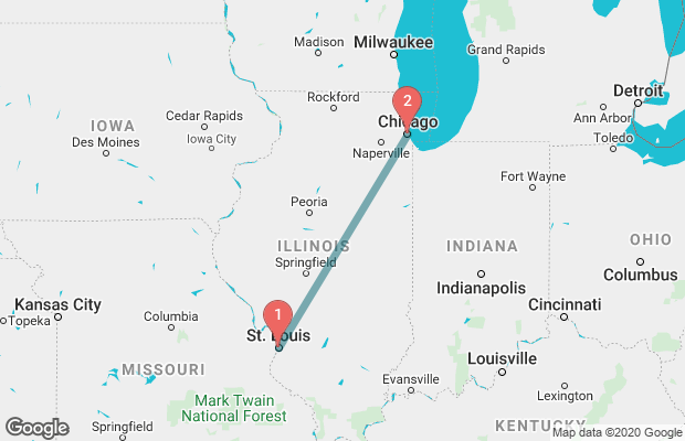
Image 8: Chicago to St. Louis route. (Source wanderu.com)
Grand Paris Express construction site tour
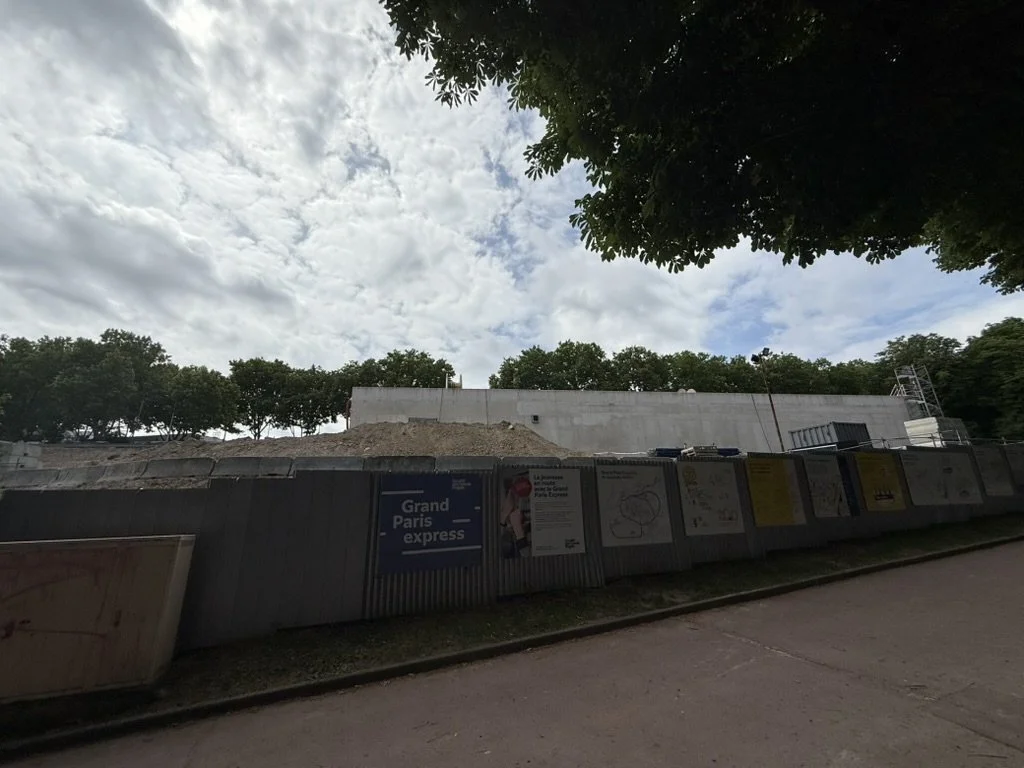
Image 9: Site of Grand Paris Express Line 15 going through Parc Henri Barbusse through Paris’s outer Issy-les-Moulineaux neighborhood.
During our last full day in Paris, we got an up-close look at the construction of the Grand Paris Express, a massive expansion of the Paris Metro mostly in the outer communities and suburbs of the region.
Here is a quick overview of the project by the numbers:
200 km (120 miles) of new metro lines
4 new lines: Line 15, 16, 17, & 18
2 line extensions: Line 11 & 14
68 stations
Speeds of 55–65 km/hr (34–40 mph)
100% automatic.
90% underground.
3 million passengers per day
2-minute frequencies during rush hour
2030 scheduled completion
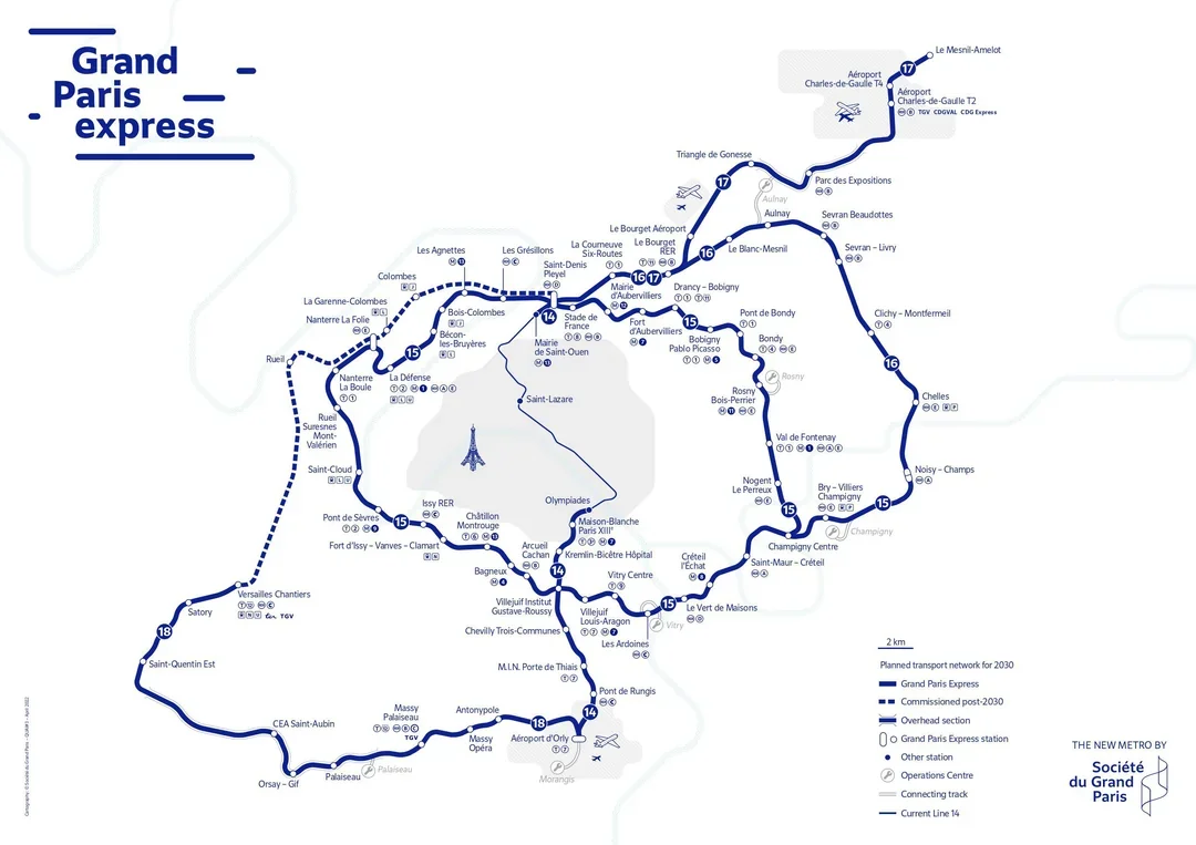
Image 10: Grand Paris Express full project map. (Source: Reddit)
The main goal of this project is to improve travel between outer suburbs without having to go through the city center. One of the construction site displays we walked past on our tour explained this really well by using specific examples of travel scenarios between two outer suburbs (see Image 11).

Image 11: Construction site billboard explaining the benefit of inter-suburb travel with new periphery lines as opposed to the current radial network. (Source Transit Visions)
Chelles to Stade de France: 41 min -> 27 min
From Chelles, an eastern suburb of Paris, to the Stade de France, the national stadium of France, located in a northern suburb, is currently about a 40-minute journey.
With the new lines 15 and 16 (see Image 13), not only will the trip be cut down to less than half an hour, but one can travel directly to the location around the outside of the city center. No more traveling into the heart of Paris to change from one service to another (see Image 12).

Image 12: Screenshot of Google Maps directions between Chelles and Stade de France. (Source: Google Maps)

Image 13: Grand Paris Express map between Chelles and Stade de France. (Source Hektor, accessed via Wikipedia; edited by Transit Visions)
Montfermeil to Villejuif: 1h 24 min -> 32 min
Travel between Montfermeil, a northeastern suburb, to Villejuif, a southern suburb, currently takes an hour and a half to two hours.
When Metro lines 15 and 16 (see Image 15) open, the journey will be chopped down to closer to half an hour.

Image 14: Screenshot of Google Maps directions between Montfermeil and Villejuif. (Source Google Maps)

Image 15: Grand Paris Express map between Montfermeil and Villejuif. (Source: Hektor, accessed via Wikipedia; edited by Transit Visions)
This project is bigger than transit
A transit expansion project of this magnitude is very impressive. When completed, 98% of the Paris metro region’s population will be within 2 kilometers (~1.2 miles) of a metro station. However, going beyond just building new metro lines, the Société des Grands Projets—the company delivering the Grand Paris Express for the regional government—is working with local communities to carry this expansion out as a full-scale urban renewal project.
Our host showed us a couple of the more than 100 new real estate developments in Grand Paris Express station areas that the Société des Grands Projets aims to initiate by 2030. The organization has also acquired more than one million square meters (roughly 10.7 million square feet) for this development to take place across the region.


Images 16 & 17: Pictures of new buildings under construction around the future Grand Paris Express station area in the Issy-les-Moulineaux neighborhood. (Source: Transit Visions)
Stay tuned for more!
The Paris (and Strasbourg) leg of our trip gave a great look into a variety of transit projects and experiences.
Our next stop in Lyon was solely focused on the major improvement project of Gare de Lyon-Part-Dieu, which is another really impressive project. I’m very excited to write about it and share with you in the coming days!
Regional rail for a more connected Jacksonville
Jacksonville's First Coast Commuter Rail has given us a glimpse of what's possible. Yet, like other bold ideas for transit in the U.S., the process has dragged out and is still just an idea.
Like most midsize major American cities, Jacksonville once had the ambition to enhance transit with bold ideas. But, also like most American cities, it struggled to make these projects come to life.
After almost two decades of planning and studies, the city’s First Coast Commuter Rail (FCCR) initiative has made little progress toward actually becoming a reality. According to my hours of deep research—and my conversation with a plugged-in transit advocate from the Jacksonville area—it’s pretty clear that regional rail is not happening anytime soon, as there have been no public updates on FCCR since the end of 2023. Further, JTA is focusing on other flashy projects that serve no real purpose and are an expensive alternative to adding a few new bus routes.
But still, as a frequent visitor, I wanted to look more into JTA’s plans and the potential for a great system.
The evolution of FCCR proposals
In 2008, JTA hired a consultant to conduct a feasibility study to assess the different route options for the service. The report, completed in July 2009, started by identifying 9 possible corridors. After briefly examining each one, the study selected the top 3 to evaluate more in-depth.
The final 3 corridors were (also see Image 1):
CSXT Kingland Subdivision: Runs north up past Jacksonville International Airport into Nassau County, terminating in Yulee.
CSXT Sanford Subdivision: Runs southwest to Clay County, terminating in Green Cove Springs. (A segment of Amtrak’s Floridian and Silver Meteor routes).
Florida East Coast Railway (FEC) Main Line: Runs southeast into St. Johns County, terminating in St. Augustine.

Image 1: Top 3 corridors in the 2009 study. (Source: JTA)
In the end, the FEC Main Line to St. Augustine was the selected corridor for FCCR service.
Bringing trains back to downtown
Jacksonville’s current Amtrak station is about 5 miles northwest of downtown in the middle of a multimodal freight hub. The area is not walkable, with no attractive development nearby. It is surrounded by surface parking, truck storage in industrial yards, vacant plots of land, and a train yard. (see Image 2). The only housing that is close by is low density and across a wide and busy stroad.

Image 2: A Google Earth screenshot of the current Jacksonville Amtrak station and the surrounding area. (Source: Google Earth, edited by me)
A big part of JTA’s plans for FCCR was to repurpose the old Jacksonville Terminal downtown back into a train station and integrate rail service with the other travel modes at the Jacksonville Regional Transportation Center (JRTC). This would enable rail passengers to make easy transfers to JTA’s bus system, the Greyhound bus station, the Skyway monorail, and the Ultimate Urban Circulator system (currently in testing phases).
If FCCR becomes a reality and Brightline eventually follows through with plans to extend service up to Jacksonville, the city is going to need a bigger station with sufficient capacity and a better surrounding area. Reviving the old station would accomplish both:
There is plenty of space to build multiple platforms and new tracks on the FEC right of way that passes by the old Jacksonville station.
While downtown Jacksonville still needs more redevelopment, it certainly beats the current train station location.
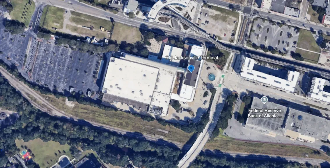
Image 3: Old Jacksonville Terminal next to the existing tracks with space to spare. (Source: Google Earth, edited by me)
JTA not only wanted to bring trains back downtown, but it also worked with the Downtown Investment Authority to lay out ambitious plans for redeveloping the surrounding neighborhood (see Images 4 & 5). A project overview from the end of 2022 and a 2023 transit-oriented development study show bold ideas for a new walkable and lively neighborhood around this new transit hub.

Image 4: Screenshot from JTA’s 2022 project overview. (Source: JTA)

Image 5: Screenshot from the 2023 TOD study. (Source: JTA and WSP USA)
The latest proposal
The most recent proposal for the FCCR network was presented in a transit-oriented development study completed by WSP USA for JTA. The report identified 15 potential stations and studied each one pretty comprehensively for potential development around them. JTA’s consultant then selected the top 7 to assess more in-depth (also see Image 6).
The 7 selected sites:
Jacksonville Regional Transportation Center (JRTC); downtown Jacksonville
Baymeadows
Avenues Walk
US 1 / County Road (CR) 210
Palencia
King Street
State Road (SR) 312
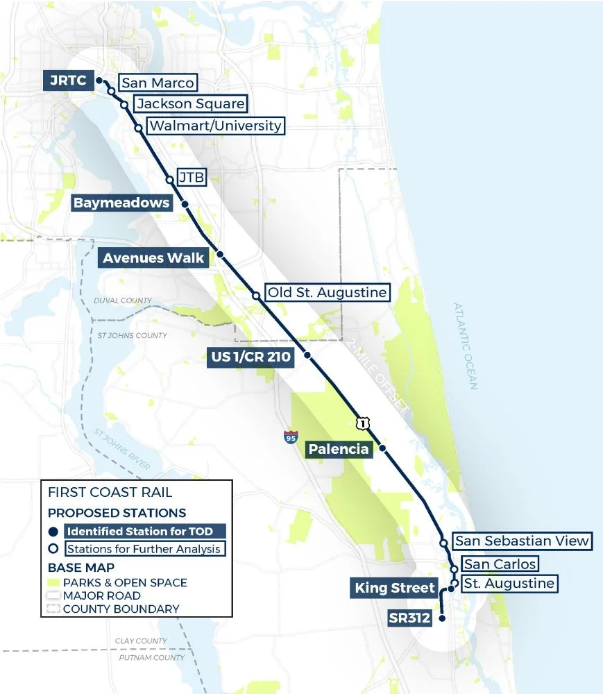
Image 6: Map of 2023 TOD study station site candidates. (Source: JTA and WSP USA)
According to the report, these locations are the top candidates for FCCR stations. The study evaluated these sites based on current readiness with population and existing developments and the best potential for future growth.
Speed and runtime
The route is 38.4 miles long and a 2022 proposal estimated a runtime of 48 minutes from JRTC to St. Augustine. However, that plan only featured four stations and terminated in downtown St. Augustine, not going all the way to SR 312 which is another two miles south. These additions would push runtimes closer to an hour.
How can we get the most out of this network?
Let’s forget about this project’s limited resources and the process that has dragged it out over so many years. I want to explore an alternate reality where JTA has the resources and will to build a robust rail network that connects the entire Jacksonville region.
Here are some of my ideas:
I have no planning, engineering, or architectural background. Part of the goal of this publication is to document my educational journey in those fields. If you have an education, working experience, or general knowledge of these concepts and railroad operations, I welcome comments with critiques, corrections, and thoughtful discussion to help me learn.
Add service on the north and southwest corridors
Investing in service in all three corridors would create a complete network covering the Jacksonville region and spark new growth throughout it.
Through-running for better connectivity
Through-running is exactly what it sounds like. It is where regional trains come from one branch of stops in suburban towns, run into the major city center, and then continue onto another branch to surrounding suburban towns on the other side.
Image 7 is a great visual aid for understanding through-running created by Liam Blank, a New York-based Urban Mobility Strategist who has written several great articles on the topic.
Image 7: Graphic comparing traditional stub-ended commuter rail to through-running regional rail. (Source: Liam Blank, accessed via liamblank.com)
What would through-running look like in Jacksonville’s regional rail network?
Northbound trains from the southeast branch will come into Jacksonville, stop at the station, and then continue north to the Yulee branch; southbound trains will go from Yulee to St. Augustine.
Trains will terminate and turn around at the end of each branch, not at JRTC. This creates a regional rail line that connects St. Augustine to Yulee and everywhere in between with a one-seat ride, no transfers necessary.

Image 8: Map from 2009 study, showing the coverage if the Yulee and St. Augustine branches were connected. (Source: JTA)
To make this a reality, it will require some work.
As shown in Image 9, new tracks will have to be built from the TTX Acorn Yard through the industrial yards and an old abandoned railway that runs through the center of the city that was turned into a walking trail.
The repurposed walking trail—the S-Line Urban Greenway—will eventually connect to the existing right of way that runs north up to Yulee.

Image 9: Map of downtown reviving abandoned downtown right of way to connect southeast branch to northern branch. (Google Earth, edited by me)
If you look closely at the map from the 2009 proposal, it appears repurposing the trail back into a railway was part of the original plan for the northern corridor.

Image 10: Close-up screenshot of the 2009 corridors in Jacksonville city center. The north branch runs a similar alignment to the existing walking trail. (Source: JTA)
We can also tell by looking closer at the map why through-running on the southwest corridor is not possible as it is currently laid out relative to JRTC. If you look at the screenshot from openrailwaymap.org (Image 11), southwest trains would have to connect to the tracks that approach JRTC from the northwest. This means trains cannot run straight through the station and just continue north onto the Yulee corridor; they would have to turn around.
That is not through-running.

Image 11: Screenshot of OpenRailwayMap of downtown Jacksonville. (Source openrailwaymap.com)
The only through-running route possible is St. Augustine to Yulee. While most passengers from St. Augustine may not be looking for a direct trip to Yulee, there are still many travel possibilities in between.
The idea of through-running sounds even better if some trains went directly to Jacksonville International Airport.
New right of way to the JAX terminal
Building a station along the existing right of way to Yulee with a shuttle service would be a lot easier and cheaper, and is not a terrible plan. But trains running directly to the terminal would truly be a game-changer. A one-seat ride without transferring to a shuttle bus is always better and will make the regional rail service a more attractive travel option.
On Google Earth, I sketched two potential routes (orange and blue) that branch off and carry trains between the northern main line to Yulee (green) and a new approach to the terminal (yellow).

Image 12: Screenshot from Google Earth with my sketches for potential direct connection to JAX terminal. (Source: Google Earth, edited by me)
Terminal approach on Airport Road

Image 13: Screenshot from Google Earth with my sketch for the route approaching the JAX terminal. (Source: Google Earth, edited by Transit Visions)
Airport Road is a wide road with a good-sized median that could easily fit a new elevated railway. Once trains reach the loop, they will run parallel to car traffic—counterclockwise—on the inside of the loop (to the left of the road).
A new small station will be built right next to the existing parking garage or somewhere close that allows a direct walk to the terminal. After droping off and picking up new passengers, trains will depart and continue running along the road until they reach the end of the loop and merge back into the main artery over Airport Road.
This is the easy part of building a direct connection to the airport. The hard part will be branching off the existing right of way to Yulee and connecting it with the Airport Road elevated track.
At a glance, I see two options.
Branch #1: Airport Center Drive

Image 14: Source: Google Earth, edited by me
This option starts with a new ramp that will branch off from the main line to Yulee and connect to an elevated track in the middle of Airport Center Drive. The right of way will continue west toward Interstate 95 where it will connect to the approach on Airport Road.
Like Airport Road, Airport Center Drive is also a pretty wide road separated by a spacious median, making it a suitable corridor for an elevated track. The issue here is crossing I-95, which passes over Airport Road. So if an elevated railway is built off the initial branch and connects to an elevated railway on the other side, it’ll have to be really tall.
Branch #2: I-295 and I-95

Image 15: Source: Google Earth, edited by me
The second option is to build tracks where trains branch off the Yulee line at I-295, and then run along I-95 until it reaches Airport Road where it will connect to the approach.
While building around the highway may be tricky, there appear to be some options to construct elevated tracks between medians and ramps over and around car traffic to make this route to connect to Airport Road possible.
Let’s reimagine daily travel in America.
I want to explore the possibilities for a future with safer, cleaner, more comfortable, more equitable, and more efficient travel transit-deficient regions like Jacksonville.
We can make them happen. But we have a lot of work to do, and it starts with breaking down the stigmas and myths that have shaped the perceptions of mass transit in this country. Part of that is exploring what is possible with fully funded investment in improving and expanding our systems.
Presenting vision.
Day trips are better by train
Fast and frequent high-speed rail between cities would make easy day trips a reality.
I just had my biggest culture shock since moving to New York, and it has inspired me to write about something I think is an underrated benefit of high speed rail and frequent intercity rail service.
I recently booked a day trip between New York and Philadelphia on Amtrak’s Northeast Regional. While it’s not a high speed train, having this kind of convenient travel mode, which was also quite inexpensive, is enough for this guy from the Midwest to appreciate.
It made me think that if other major cities were connected by actual high speed trains (and/or frequent departures between cities really close to each other), this kind of travel would be possible all over the U.S.
Many Americans can’t even begin to comprehend this kind of travel. So, I was inspired to write an article that could maybe stimulate the imagination of the car-conditioned American, or how the one crazy transit-obsessed family member (me) can back to their home suburb for the holidays and pitch high speed rail to their family.
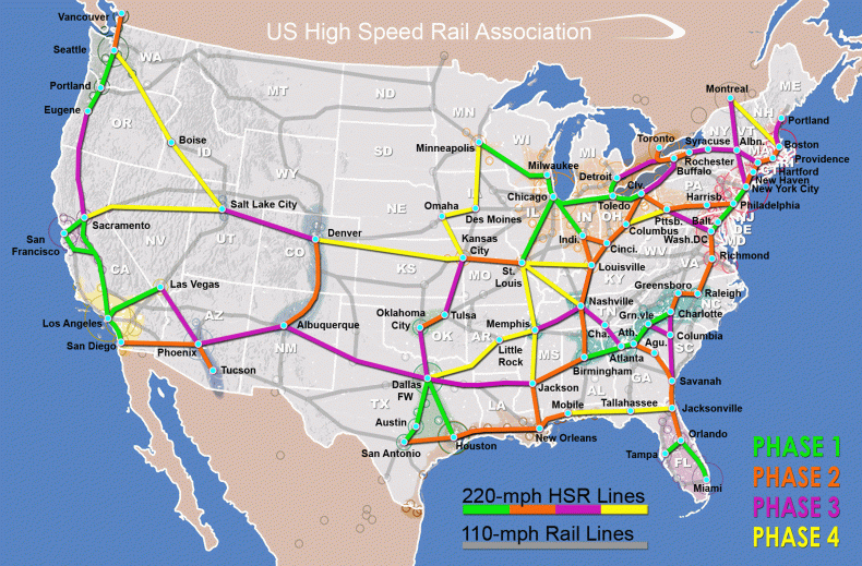
Image 2: U.S. High Speed Rail Association’s map (Source: USHSR, accessed via newsweek.com)
What kind of day trips could we take?
Here is a broad list of different day trips that are possible with fast and frequent trains:
Business meetings and conferences
If the city you have to travel to is close enough to do a trip by high speed rail, it’d be nice to have the option of not paying for a hotel there and being able to return home, see your family, and sleep in your bed. Especially if you’re only traveling for a couple of meetings or a one-day conference.
Plus, you get to do work before and after while on the train. If you were driving, you couldn’t do that!
Visiting family and friends
When I lived in St. Louis, visiting family and friends in Chicago and Kansas City was not difficult, but it certainly wasn’t convenient, either. It was always easier to consolidate visits into a few days in one city or the other, and with busy schedules, sometimes plans like that are prone to falling apart.
But with fast and frequent trains, day trips on weekends for family lunches or a quick round of golf with my friends could’ve been more a regular occurrence.
Sporting events and festivals
Is your team playing its rival in a nearby city? Is your favorite band playing in a music festival in a city near yours?
Well, it’s not only faster to get there by high speed train, it’s also more comfortable and fun to sit around a table with your friends than cramming into a car. Plus, if you want to pregame with a few drinks (responsibly) or need a snack on the way home, you can just walk to the café car!

Image 3: Source: switzerlandtravelcentre.com
Quick visits home for college students
Many high speed rail corridors have college towns with large universities along the way and are large enough to justify a stop. Those smaller cities or college towns likely have other small colleges in addition to the large university, and the major cities at each end of the corridors probably have a good number of students as well.
As a college student who didn’t venture far from home, imagine being able to hop on a high speed train to visit family on Mother’s Day or Easter Sunday for a few hours and then be back in the evening. Plus, not only would the journey be faster than driving, but you can also do your Sunday studying on the train journey both ways that you can’t do behind the wheel.
The importance of frequency and affordability
The key to making day trips a viable option between cities is not only fast trains, but frequent departures.
Cars offer the unmatched convenience of being able to leave whenever you want, you have full control over your schedule. But a minimum of two departures per hour from about 6 or 7 a.m. to about 9 or 10 p.m. makes high speed rail more competitive with driving in terms of convenience.
Every city pairing should run this kind of service to maximize the potential of its corridor, and it would unlock so many possibilities to make day trips between major cities more viable. On my upcoming day trip, I leave New York at around 7 a.m. so I can show up early for a conference that starts at 9. In the evening, my train back leaves Philadelphia at 8 p.m., which is great, so I can stay after the conference and network a little bit.
Early morning train schedule from New York to Philadelphia:

Image 4: Early morning trains from NYC to Philadelphia. (Source: Screenshot of Amtrak schedules)

Image 5: Evening trains from Philadelphia to NYC. (Source: Screenshot of Amtrak schedules)

Image 6: More late-night trains from Philadelphia to NYC. (Source: Screenshot of Amtrak schedules)
Making these trains affordable is also a huge factor, especially when booking on short notice. For my day trip to Philadelphia, I was initially considering staying the night, but after looking at hotel room prices and then seeing that my Amtrak trip could be as low as $30, I didn’t think twice about booking my return train in the evening instead of the next morning.
Yes, my upcoming trip is on a conventional train, and high speed rail is a much different beast in terms of upfront and operating costs, and operators need the revenue. But affordable high speed rail is possible; just look at Spain. I went through the train schedules for a day trip between Barcelona and Zaragoza and was able to plan a day trip for as low as $50 with a pretty optimal schedule (see Image 7). It’s worth mentioning that I was able to get this fare THREE DAYS BEFORE the trip.

Image 7: Planning a day trip between Barcelona and Zaragoza on thetraninline.com. I went online to do this on Friday, March 14, and was able to get this price for a trip three days later, on Monday, March 17. (Source: Screenshot of planned trip via thetrainline.com)

Image 8: Map of Barcelona to Zaragoza, a corridor that’s about 200 miles. (Source: spanishtrains.com)
Let’s reimagine daily travel in America
The voices that look for any reason not to build bold new transit infrastructure in the U.S. have dominated the conversation for too long.
At Transit Visions, I want to add a voice to the fight for better transit. I not only want to be an advocate, but also help shift the paradigm of our country’s mindset regarding mass transit and fully explore what is possible for better daily travel within our cities and between them.